The Trail, Pedestrian, and Bicycle Master Plan identifies projects that will support the vision for a more comfortable, connected active transportation network in Milpitas.
Informed by previous plans, data analysis, and public feedback, the projects presented in the plan seek to:
Pedestrian improvements identify opportunities to create a safer, more comfortable, and better-connected network for those who walk or use assisted mobility devices in Milpitas.
Projects identified complete sidewalk gaps and improve safe roadway crossings within two distinct areas.
Learn more about the pedestrian project types here
Neighborhood Signalized Improvements
- Curb extensions, raised crosswalks, or medians to slow vehicle speed
- Remove slip lanes
- Install advanced stop bars
- Upgrade curb ramps to comply with ADA standards
Neighborhood Unsignalized Improvements
- High visibility crossings and signage
- Improve lighting and sight lines
- Upgrade curb ramps to comply with ADA standards
Commercial Signalized Improvements
- Reduce curb radius to slow turning speeds; remove slip lanes
- Shorten crossing distance through curb extensions
- Improve signals, including Leading Pedestrian Interval, countdown signal, and No Right on Red
Commercial Unsignalized Improvements
- Evaluate application of pedestrian hybrid beacon or or RRFB for mid-block crossings
- Reduce curb radius to slow vehicle speeds
- Shorten crossing distance through pedestrian refuge island, curb extensions, or other traffic calming feature
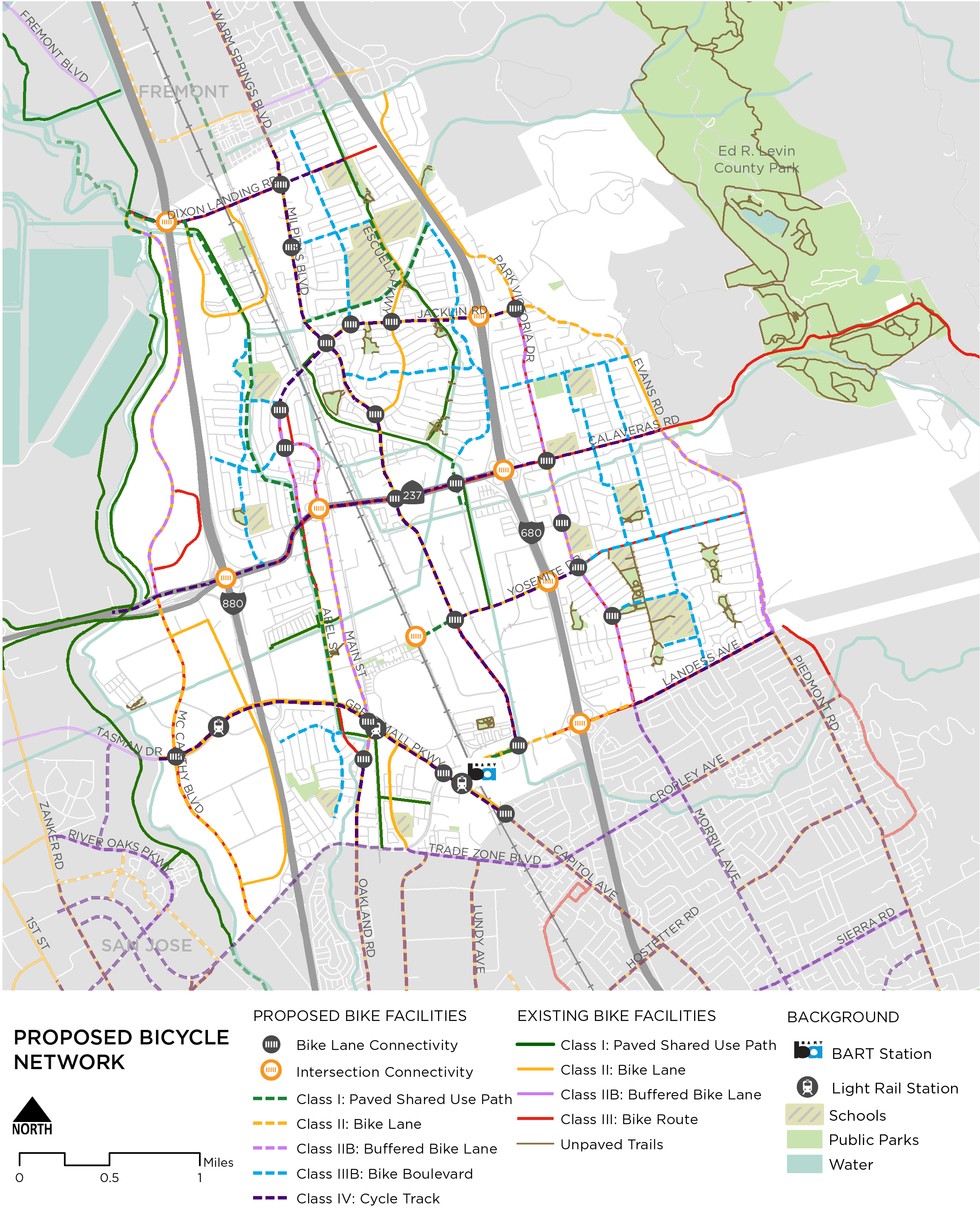
Bike network improvements support a better connected, more complete bike network in Milpitas.They include linear improvements to improve travelling along a route and spot improvements to improve conditions at specific locations.
Neighborhood routes offer alternatives to high-speed roadways, while increased separation on key corridors support cross-town connections. The paved pathway network, also displayed on the map below, is a vital component of a low-stress network. The identified improvements create safer routing options through a variety of on-street facilities and provide connections to transit, jobs, commercial centers, and educational opportunities.
Learn more about the bicycle project types here
Bicycle Network Improvements
- Bike Lane Connectivity: Continue bike lane striping through the intersection approach to define operating space for people bicycling and enhance predictability
- Intersection + Connectivity Improvements: Complex intersection may require reconfiguration and additional study to support low-stress network connectivity
The proposed Trail Network Recommendations seek to provide safe and comfortable transportation routes and enhance recreational opportunities for residents.
Proposed paved shared use paths connect with existing city and regional trails and on-street bicycle and pedestrian facilities to provide access to transit, schools, and parks. In addition to new paths, new access points, improved crossings, and designated trailheads support network objectives.
Learn more about the shared use path project types here
Trail Spot Improvements
- New Connections: Opportunities for new connections to the trail network to expand access
- Trail Access Improvement: Opportunities for improved access to the existing trail network and improved roadway crossings that prioritize low-stress travel
- Trailhead Improvements: Key access points for the network, often in parks or other major destinations. Include amenities such as signage, restrooms, bicycle parking, and system maps


