Today, people living and working in Milpitas rely on driving to get where they want to go. In addition to the 76,231 people living in Milpitas, the population nearly doubles each day as people travel to the city for work. These numbers are expected to continue growing.
With more people traveling in and around Milpitas, more travel options are needed. The new BART station is a significant opportunity to reimagine travel in the area; new bicycle, pedestrian, and trail improvements can expand access to BART, bus, and more.
Active transportation networks support more than just commute trips. They also connect people to other destinations, including access to schools or services, as well as recreational opportunities. To better understand opportunities for active transportation, the Master Plan considers:
- Where are there gaps in the network today?
- What are the barriers to travel?
- Where are people trying to go?
- Where are collisions occurring?
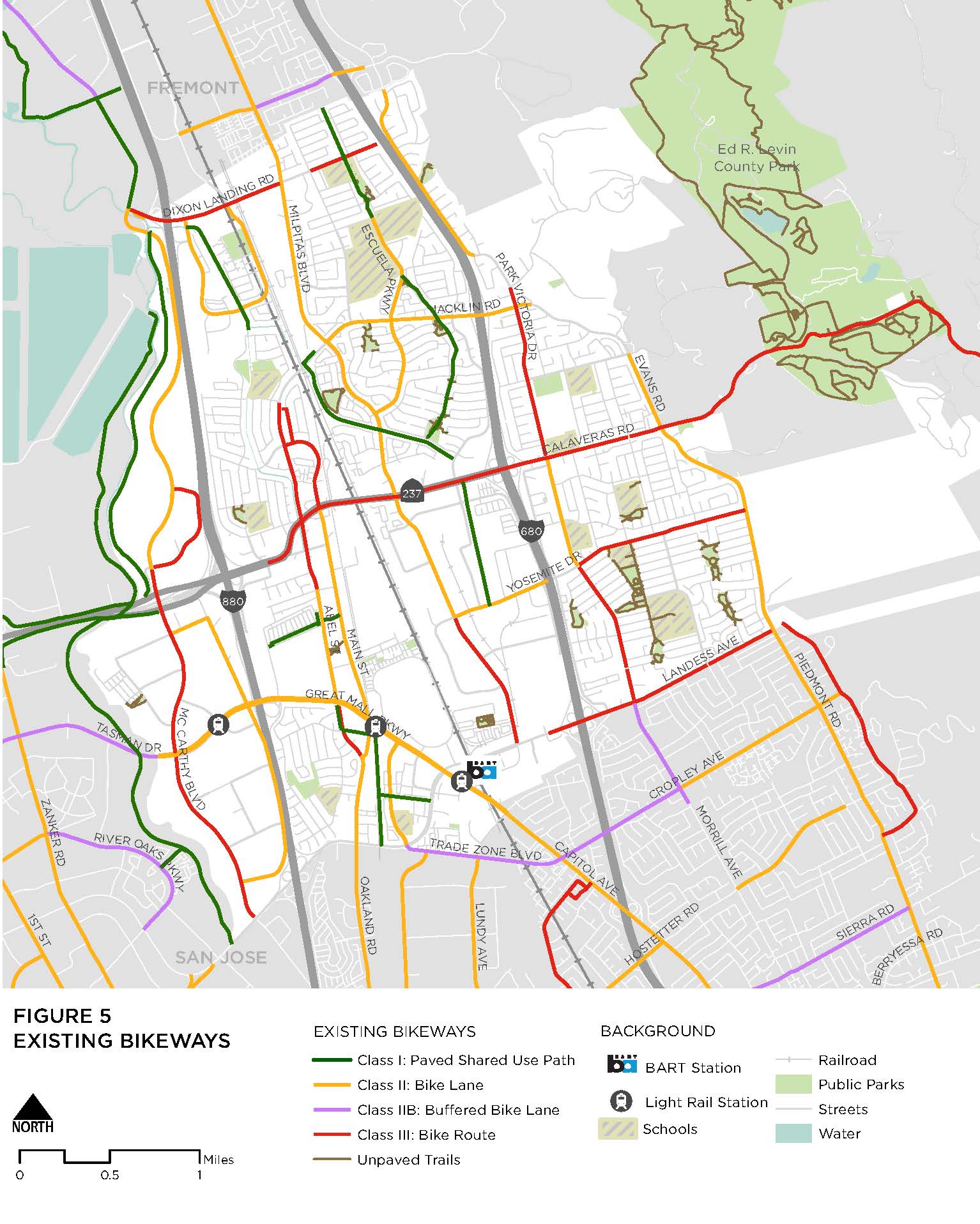
Existing Networks
Expand the sections below to learn about today’s active transportation networks.
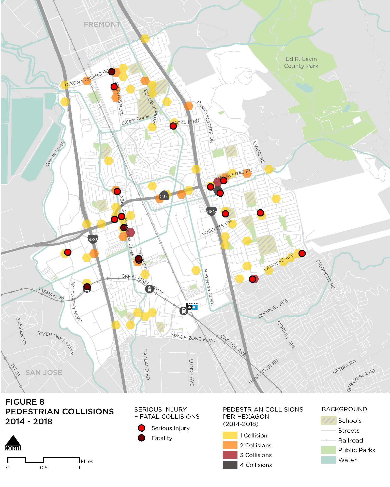
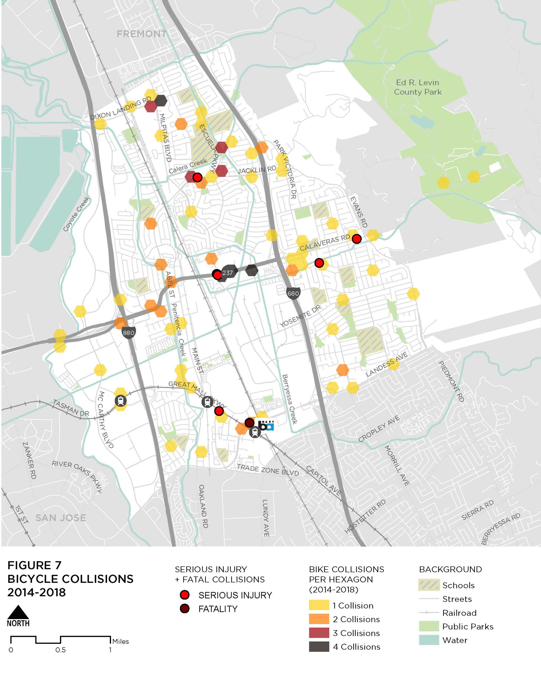
Safety
Collision data from 2014 through 2018 shows that bicyclists and pedestrians are disproportionately represented in crashes resulting in severe injuries or fatalities. As shown in the chart below, although bicycle and pedestrian involved collisions occurred less often than those involving a motor vehicle, people biking and walking were killed or severely injured more often.

These collisions most often occurred along major roadways and at intersections without a signal. Improving intersection safety and providing safer, more comfortable locations to walk or bike can support active transportation in Milpitas.
- 84 total collisions
- 16 severe injuries
- 4 fatalities
- 45% occurred in a crosswalk
- Occurred most frequently along major roadways, such as Calaveras Road, Landess Avenue, and Dixon Landing Road.
- Most pedestrian fatalities and severe injuries occurred along Abel Street and Park Victoria Drive.
- 103 total collisions
- 55% occurred at an intersection
- 7 severe injuries
- 1 fatality
- Occurred most frequently along major roadways, such as Calaveras Boulevard, Montague Expressway, and Jacklin Road.
- Most severe injuries and fatalities occurred along a major roadway and at unsignalized intersections with no bicycle facility.
Regional Connectivity
Milpitas is an integral part of the regional bicycle network, providing opportunity to connect to a variety of destinations in nearby cities and beyond. Examples include:
- Connections to the cities of San Jose and Fremont support access to jobs, services, and recreational activities
- Coyote Creek Trail is part of the regional San Francisco Bay Trail, a planned 500 mile trail alignment along the San Francisco Bay
- The 2018 Regional Bicycle Master Plan (VTA) designates four corridors in Milpitas as priority bike corridors
Key Findings
- The existing active transportation network supports limited travel by foot or by bike.
- High-speed roadways, railways, and highways impede safe, connected travel.
- An expanded network of connected routes that support residents and visitors of all ages and abilities as they travel to destinations in and around Milpitas. This includes low-stress infrastructure, such as separated bikeways and shared use paths, that provide greater separation between people walking or biking and people driving.